


A Primer on Intermap
Accelerating, and then accelerating some more..

Introduction
Intermap (ITMSF) is a geospatial intelligence company focused on the creation, analysis, and provisioning of 3D terrain data and high-resolution thematic models of the Earth’s surface. The company offers a comprehensive suite of remotely sensed, 3D and multidimensional digital elevation models (DEMs), precise, ground-true ortho-rectified images, map layers, thematic models, related digital infrastructure, software products, and solutions. These products leverage available data sources globally, at any time.
Products
Intermap's IFSAR (Interferometric Synthetic Aperture Radar) technology is an advanced airborne mapping system that captures high-precision 3D geospatial data. It produces three main products:
Digital Surface Models (DSM) measure the top surface, including vegetation and buildings. Used for applications like cell tower line-of-sight and property development.
Digital Terrain Models (DTM), a "bare earth" model with vegetation and man-made features removed. Supports applications like flood modeling and agricultural analysis. Intermap uses proprietary radar that can penetrate obstructions to build highly accurate 3D DTMs.
Orthorectified Radar Images (ORI), geometrically corrected grayscale images (Multi-Frequency Orthorectified Radar Imagery) used for extracting terrain features and other mapping applications, with a horizontal resolution of up to 25cm.
This technology uses dual radar antennas to measure elevation, operates in all weather conditions, and integrates GPS/INS for precise navigation. It can map large areas quickly with vertical accuracies of ≤1 meter.
Applications include infrastructure planning, defense, disaster management, and resource mapping. Intermap’s NEXTMap program has created extensive elevation datasets for countries worldwide, supporting large-scale geospatial projects.
Value-added Data Products: Created using core data and tailored to customer needs. Examples include custom contours, terrain-derived hydrology and coastline datasets, slope and Aspect maps, hillshade images and clutter and Land cover data.
Data as-a-Service (DaaS) and Software Solutions: Intermap offers its data and analytics through cloud-based services and software.
InsitePro: Configurable insurance underwriting software for natural catastrophe risk assessment.
Aquarius Software and Solutions: Flood risk data, models, and software.
NEXTView: High-quality configurable data solution for aviation markets, providing terrain and obstacle awareness. It is the only globally certified dataset for the commercial airline cockpit.
Solutions for navigation in aviation (including helicopters and drones).
Solutions for RF propagation management and measurement for satellite communication companies.
Competitive Advantage
Proprietary Radar Technology: Patented, dual-use, multi-frequency radar technology developed with the U.S. Department of Defense (DARPA). This allows for simultaneous collection of precise latitude, longitude, and elevation data, even in poor visibility (night and cloud cover). The P-band sensor offers unique foliage penetration capabilities. Intermap believes this technology gives it a strong leadership position.
NEXTMap Global 3D Geospatial Library: The world's largest commercial 3D terrain data archive, built over an extended period with proprietary and third-party data. This library represents a significant barrier to entry.
Patented Processing and Data Fusion: Employs patented processing engines and unique data fusion technologies like IRIS (Intelligent Resolution Improvement System). IRIS combines data from various sources (radar, LiDAR, satellite) to create enhanced DEMs.
Dual-Use Technology and Government Partnerships: Collaboration with the U.S. Department of Defense provides insights, funding for R&D, trusted partner status, and the ability to commercialize military-grade technology. Intermap has strong relationships with agencies like the NGA and USGS.
Business Model Focused on Data as a Service (DaaS) and Software Subscription: This model yields high margins and growth with recurring revenue. At least 60% of revenue is from software subscriptions. The churn rate is very low at 1-2% annually.
Ease of Use and Industry-Specific Solutions: Focuses on delivering data and solutions that are easily integrated into customer workflows without requiring specialized GIS expertise. Tailoring applications to specific industries creates cost-effective and sticky solutions.
Global Scale and Extensive Experience: Long history in the geospatial industry, with global data coverage, positioning Intermap as a reliable provider for large-scale projects.
Business Model
The accumulated data the company generates in acquisition services projects remains company property and is increasingly used as input in a host of geospatial intelligence through Data as a Service (DaaS) and software subscriptions. Through subscription services, Intermap can sell the same data to multiple customers.
Acquisition Services (Fee-for-service contracts)
This segment involves project-based work, typically with sovereign clients, where Intermap is contracted to collect imagery and/or digital elevation models (DEMs) for a specific area and purpose.
Each project is tailored to the client's specific needs. Intermap utilizes its proprietary radar sensor technologies mounted in Learjet aircraft for data acquisition, allowing for data collection at any time of day, including under cloud cover, tree canopy, or darkness.
These projects have historically generated significant revenues and margins, although they can be unpredictable in timing and value.
Intermap retains ownership of the data it gathers for its acquisition services segment. According to its End User License Agreement (EULA) and other policies, the data is licensed to customers rather than sold. The data can subsequently be used for its growing DaaS (Data as a Service) business, enabling the company to sell the same data multiple times and add value to it.
Value-added Data Licenses (Geospatial database licensing)
Intermap creates and updates its worldwide NEXTMap database of location-based information, which is then licensed to a broad group of customers.
The NEXTMap database is described as the world's largest commercial 3D geospatial library. Intermap adds value to raw data from its own sensors and other sources (including LiDAR, satellite imagery) through its patented Intelligent Resolution Improvement System (IRIS) and proprietary software to enhance its usefulness for clients.
These products are provisioned as a service or through a perpetual license.
Software and Solutions
This segment involves Intermap licensing its proprietary software applications, such as InsitePro (for insurance underwriting), Aquarius (flood risk data, models, and software), and NEXTView (for aviation markets).
These licenses are often through pre-paid annual subscriptions, generating recurring, predictable revenue, with at least 60% of the revenue being software subscription-based.
Services are also delivered on a contract-by-contract basis to support clients. NEXTView is also licensed for drone applications through annual subscriptions.
Value Proposition
High-Accuracy and High-Resolution 3D Geospatial Data: Enabled by proprietary radar technology.
Global Scale and Coverage: Through the NEXTMap library.
Data Integration and Fusion: Combining data from multiple sensors through IRIS.
Ease of Use and Accessibility: Delivering data and solutions that can be easily integrated.
Industry-Specific Solutions: Tailoring products and software to specific industry needs.
Timely Delivery and Scalability: Leveraging technology and processing capabilities.
Customer Segments
Government Agencies
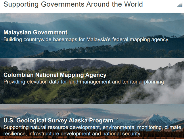
National mapping agencies, federal entities (NGA, USGS), and the U.S. Department of Defense (Air Force, DARPA). Intermap helps governments with base mapping, infrastructure planning, natural resource management, and national security. They have worked with more than 50 countries.
Commercial Clients

Insurance Companies for underwriting natural catastrophe risk, particularly flood (e.g., Vienna Insurance Group, Aon).

Aviation Authorities and Airlines for terrain and obstacle awareness (NEXTView with Lufthansa Systems).

Drone and Helicopter Companies for precise navigation.
Space and Orbital Sensor Companies utilize terrain data.

GIS Software Users Intermap's data feeds into various platforms.
Telecommunications Companies for cell tower placement and RF propagation.
Other sectors include natural resource companies, environmental consultants, road transportation and logistics, land use planners, agricultural companies, consumer recreation apps, navigation, simulation, and visualization companies.
Indonesia contract
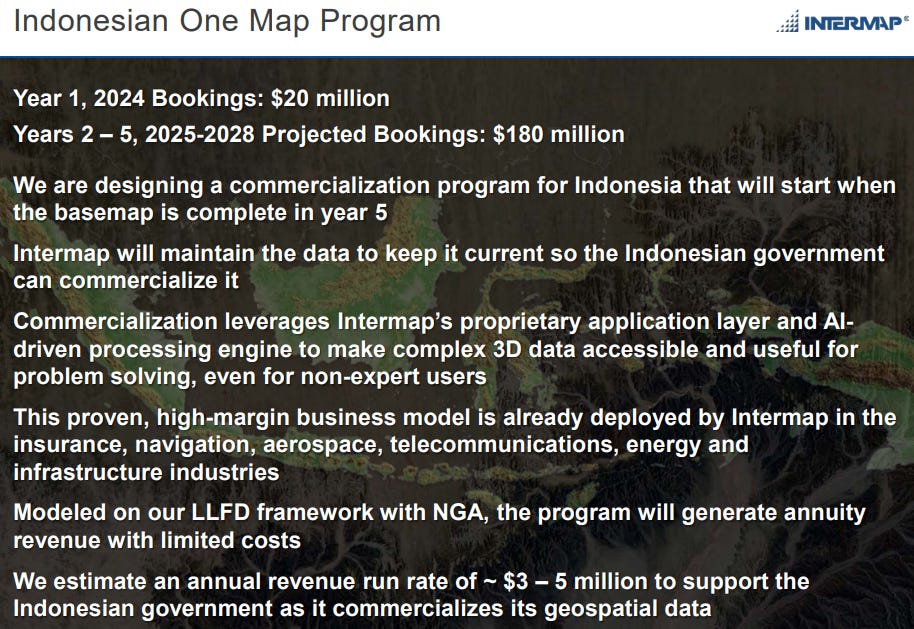
The Indonesia project is a significant example of Intermap's Acquisition Services segment. It is a $20M first phase contract with the Indonesian government that spans a 12-month period.
It is a fee-for-service contract with the Indonesian government, classified under Intermap's Acquisition Services segment. The first phase of the contract is valued at $20M for 10% of the country
The project involves project-based work where Intermap is contracted to collect imagery and/or digital elevation models (DEMs) for a specific area and purpose. The project is tailored to the client's specific needs.
Revenue from this contract can be recognized using the percentage-of-completion method, with Intermap having completed 60% of the work by year-end 2024.
The World Bank has already approved the additional 90% of the project, which has a 4-year period, and Intermap is in pole position to win this as well.
There are other programs, and the company has a healthy pipeline as well.